
North Korea has officially modified its map of the Korean Peninsula to reflect its “two-state theory,” marking the first confirmed instance of such a revision.
According to China’s social media platform Xiaohongshu, a Chinese user studying Korean, posted an image of the “Choson (Korea in North Korea) Map” on January 28, stating that it was published by North Korea’s state-run Map Publishing House. However, the user did not specify how he obtained the map.
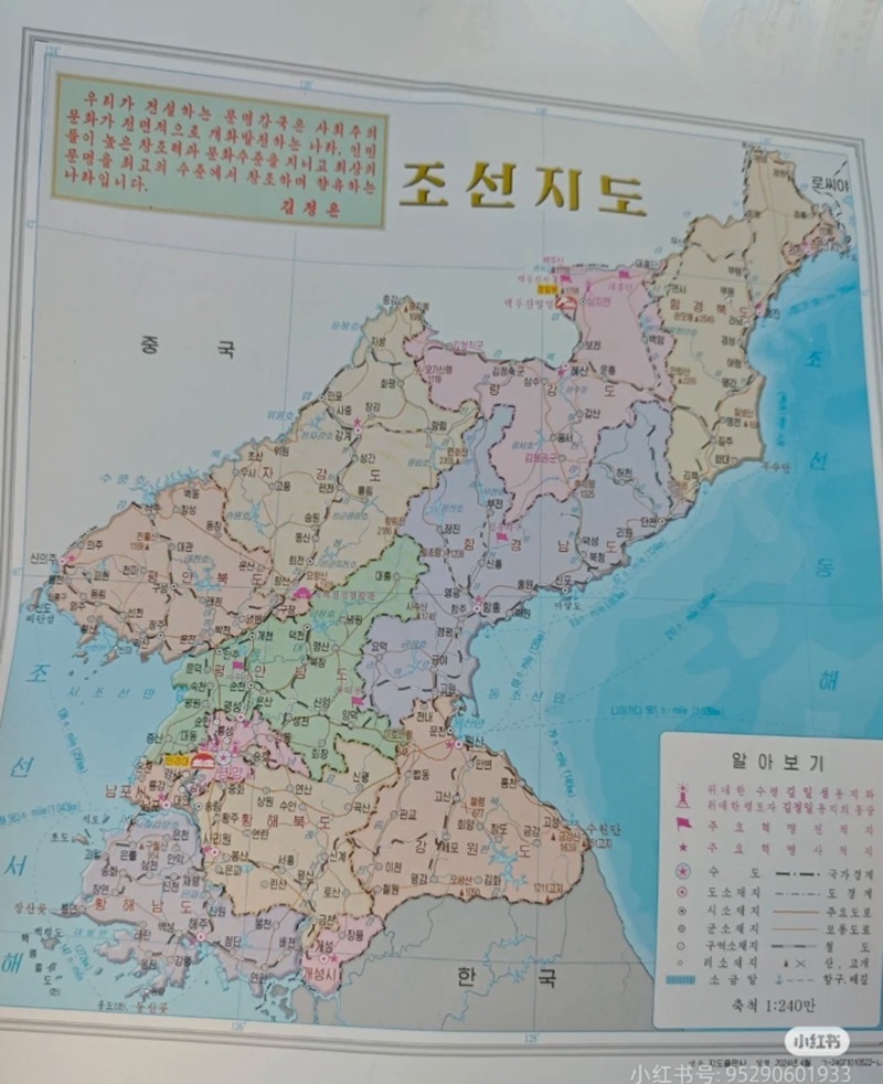
According to Newsis, the new map differs significantly from previous versions. In the photo uploaded online, the entire South Korean territory appears grayed out with only the word ‘Hanguk’ (Korea) written over it—a stark departure from North Korea’s past maps, which detailed South Korea’s administrative divisions.
This is the first time North Korea has used the term ‘Hanguk’ in an official document since Kim Jong-un declared the two-state-theory in January last year, formally erasing references to unification in state rhetoric.
The map also reflects other significant changes. The top-left corner now contains Kim Jong-un’s directive, replacing past versions that featured his father Kim Jong-il’s instructions. Additionally, the bottom-right corner of the map explicitly states “Published in April 2024.”
Past versions of North Korea’s official maps, such as those from 2012 and 2018, included detailed administrative divisions of South Korea, similar to standard maps. They also specified the geographical boundaries of the Korean Peninsula, marking the southernmost and easternmost points, including Marado in Seogwipo City, Jeju Province, and Dokdo in Ulleung County, North Gyeongsang Province.
However, these details have been completely removed from the new version, reflecting a shift in North Korea’s territorial perspective.
North Korea’s cartographic revision appears to be a direct follow-up to Kim Jong-un’s January 2023 declaration at the Supreme People’s Assembly, where he removed references to unification from North Korean policy and added a constitutional clause defining North Korea’s national territory separately from South Korea.
The removal of the Juche calendar and the replacement of Kim Jong-il’s instructions with Kim Jong-un’s suggest a move to further solidify Kim Jong-un’s independent ideological rule while distancing his leadership from the Kim Il Sung–Kim Jong il legacy.
By enshrining the two-state theory in official maps, North Korea is signaling a fundamental shift in how it perceives and projects its relationship with South Korea. Rather than viewing it as a nation to be reunified, North Korea is now portraying South Korea as a completely separate state.
BY YOUNGNAM KIM [kim.youngnam@koreadaily.com]


